1960 Map of Chowchilla
USGS Topo · Published 1961About this map
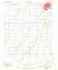
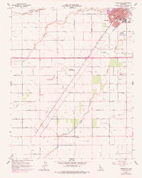
Chowchilla and the surrounding Central Valley agricultural landscape are defined here by a dense grid of numbered roads and irrigation infrastructure. The town center is organized around the Southern Pacific railroad line, featuring local institutions like Stephens Sch, Wilson Sch, and the County Fairgrounds. Beyond the town limits, the terrain is dominated by the complex water management systems of the San Joaquin Valley, including the Chowchilla River, Ash Slough, and Berenda Slough. Numerous lateral canals such as the Ashview Lateral A and Califa Lateral B crisscross the fields, supporting the dairy and crop operations that anchored the local economy. At the southern edge of the survey, the small community of Dairyland sits along the Berenda Slough, while landmarks like the Seventh Day Adventist Sch and the Chowchilla Cemetery provide important touchpoints for genealogical research in this 1960s-era landscape.
Find a feature on this map
55 named features on this map. Tap any name to fly to it.
Don’t see what you’re looking for? This feature index may not catch every label — zoom into the map to look around manually.
Map Details
Editions of this 1960 Chowchilla Map
2 editions found
Other maps of this area

1916 · Berenda
USGS Topo · 1:31,680

1918 · Bliss Ranch
USGS Topo · 1:31,680

1918 · Lingard
USGS Topo · 1:31,680

1918 · Chowchilla
USGS Topo · 1:31,680

1918 · Berenda
USGS Topo · 1:31,680

1918 · La Grand
USGS Topo · 1:31,680

1919 · Plainsberg
USGS Topo · 1:31,680

1920 · Bonita Ranch
USGS Topo · 1:31,680

1921 · Bonita Ranch
USGS Topo · 1:31,680

1922 · Pozo Farm
USGS Topo · 1:31,680