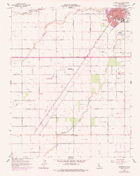
1960 Map of Chowchilla
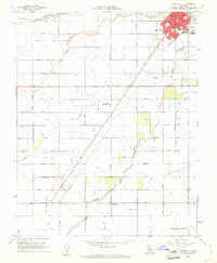
USGS Topo · Published 1977About this map
Chowchilla serves as the focal point of this agricultural landscape in the San Joaquin Valley, where the town’s grid meets the steel of the Southern Pacific railroad. The geography is defined by a sophisticated irrigation network, including the Chowchilla Canal, Justin Canal, and Ashview Lateral A, which support the surrounding farmsteads. The transition from the 1960 planetable surveys to the 1976 photorevisions illustrates the town's expansion, particularly near the County Fairgrounds and Memorial Hospital.
Find a feature on this map
45 named features on this map. Tap any name to fly to it.
Don’t see what you’re looking for? This feature index may not catch every label — zoom into the map to look around manually.
Map Details
Editions of this 1960 Chowchilla Map
2 editions found
Other maps of this area

1916 · Berenda
USGS Topo · 1:31,680

1918 · Bliss Ranch
USGS Topo · 1:31,680

1918 · Lingard
USGS Topo · 1:31,680

1918 · Chowchilla
USGS Topo · 1:31,680

1918 · Berenda
USGS Topo · 1:31,680

1918 · La Grand
USGS Topo · 1:31,680

1919 · Plainsberg
USGS Topo · 1:31,680

1920 · Bonita Ranch
USGS Topo · 1:31,680

1921 · Bonita Ranch
USGS Topo · 1:31,680

1922 · Pozo Farm
USGS Topo · 1:31,680