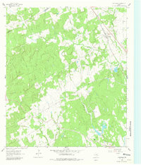
1962 Map of Chriesman
USGS Topo · Published 1980About this map
The Gulf Colorado and Santa Fe railroad serves as a central artery for this section of Burleson County in the early 1960s, threading through the community of Chriesman. The landscape is defined by the winding course of Davidson Creek and its many tributaries, including Frost Branch and Thompson Branch. This rural Texas terrain is dotted with markers of a established community life, from the Shiloh Sch and Shiloh Cem in the south to the Chriesman Cem near the rail line. Small-scale resource extraction is evident via several scattered Oil Well sites and a Gravel Pit. To the west, the Milam Co Burleson Co boundary line cuts across the drainage basins of Hooker Creek and Porter Branch, while the developing Cade Lakes area suggests a shift toward recreational water use in the post-war era.
Find a feature on this map
23 named features on this map. Tap any name to fly to it.
Don’t see what you’re looking for? This feature index may not catch every label — zoom into the map to look around manually.
Map Details
Editions of this 1962 Chriesman Map
Other maps of this area

1919 · Dime Box
USGS Topo · 1:62,500

1954 · Austin
USGS Topo · 1:250,000

1956 · Caldwell
USGS Topo · 1:62,500

1956 · Milano
USGS Topo · 1:62,500

1956 · Somerville
USGS Topo · 1:62,500
1960 · Tanglewood
USGS Topo · 1:24,000
1960 · Frenstat
USGS Topo · 1:24,000
1960 · Deanville
USGS Topo · 1:24,000
1961 · Caldwell
USGS Topo · 1:24,000

1961 · Rockdale East
USGS Topo · 1:24,000