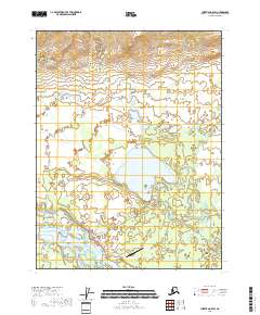
2018 Map of Christian A-5 SW
USGS Topo · Published 2018About this map
The settlement of Venetie sits along the Teedriinjik River in this 2018 survey of the Yukon-Koyukuk region. This interior landscape is defined by the complex hydrography of the Venetie Lake and Tetravun Lakes systems, where numerous unnamed ponds and wetlands are connected by small waterways like Kocacho Cr. The map documents a sparse but essential transportation network connecting the village to its surroundings. Beyond the local Venetie Airport, several functional routes extend into the wilderness, including Wood Yard Road, Big Lake Road, and Landfill Access Road. For those researching the history of travel in the region, the survey highlights traditional routes such as the Fort Yukon Trail, alongside localized paths like the Well House Trail and Wood Trail. This modern topographic study preserves the spatial arrangement of a remote community and its vital access points to the surrounding water bodies and resources.
Find a feature on this map
19 named features on this map. Tap any name to fly to it.
Don’t see what you’re looking for? This feature index may not catch every label — zoom into the map to look around manually.
Map Details
Editions of this 2018 Christian A-5 SW Map
This is the sole edition of this map. No revisions or reprints were ever made.
Other maps of this area

1951 · Fort Yukon
USGS Topo · 1:250,000

1951 · Christian
USGS Topo · 1:250,000

1955 · Fort Yukon D-5
USGS Topo · 1:63,360

1956 · Christian
USGS Topo · 1:250,000

1956 · Fort Yukon
USGS Topo · 1:250,000
1956 · Fort Yukon D-6
USGS Topo · 1:63,360
1956 · Fort Yukon D-5
USGS Topo · 1:63,360
1990 · Christian A-6
USGS Topo · 1:63,360
1990 · Christian A-5
USGS Topo · 1:63,360
2018 · Fort Yukon D-5 NW
USGS Topo · 1:25,000