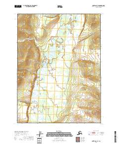
2018 Map of Christian C-1 SE
USGS Topo · Published 2018About this map
The Sheenjek River meanders through this interior Alaskan wilderness, defining the drainage patterns and valley structure within the Yukon-Koyukuk region. This 2018 survey documents a remote landscape shaped by water and elevation, marked by the extensive township and range boundaries of T32n R16e, T32n R17e, T31n R16e, and T31n R17e. The map illustrates the complex braiding and oxbows of the river as it flows across a broad floor, flanked by rising terrain on either side of the valley. With no roads or permanent settlements indicated, the map serves as a primary record of the natural topography and hydrologic features of the Christian C-1 SE quadrangle.
Find a feature on this map
5 named features on this map. Tap any name to fly to it.
Don’t see what you’re looking for? This feature index may not catch every label — zoom into the map to look around manually.
Map Details
Editions of this 2018 Christian C-1 SE Map
This is the sole edition of this map. No revisions or reprints were ever made.
Other maps of this area

1951 · Coleen
USGS Topo · 1:250,000

1951 · Christian
USGS Topo · 1:250,000

1956 · Coleen
USGS Topo · 1:250,000

1956 · Christian
USGS Topo · 1:250,000
1983 · Coleen C-6
USGS Topo · 1:63,360
1983 · Christian C-1
USGS Topo · 1:63,360
1990 · Christian B-1
USGS Topo · 1:63,360
1990 · Coleen B-6
USGS Topo · 1:63,360
2018 · Christian B-1 NW
USGS Topo · 1:25,000
2018 · Christian C-1 NW
USGS Topo · 1:25,000