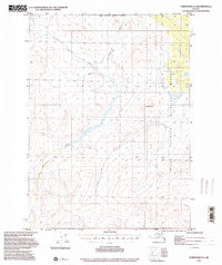
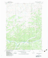
1972 Map of Christian D-3
USGS Topo · Published 2000About this map
The Christian River defines this subarctic landscape within the Arctic National Wildlife Refuge, where the river’s winding course cuts through high-latitude terrain and expansive wetlands. The sheet captures a wild corridor of the Yukon-Koyukuk region as it was surveyed in the early 1970s, specifically highlighting the North Boundary Fairbanks Meridian. The presence of a Winter Trail stretching across the northern sections of the map indicates the seasonal nature of travel and transport in this remote interior. Unlike many southern maps, this landscape is defined by its lack of permanent settlements, focused instead on natural topography and Indigenous or geographic landmarks like Chotzatdhah. The map serves as a vital record of federal land management boundaries established by the Alaska National Interest Lands Conservation Act, reflecting the transition of these lands into protected status.
Find a feature on this map
5 named features on this map. Tap any name to fly to it.
Don’t see what you’re looking for? This feature index may not catch every label — zoom into the map to look around manually.
Map Details
Editions of this 1972 Christian D-3 Map
2 editions found
Other maps of this area

1951 · Christian
USGS Topo · 1:250,000

1951 · Arctic
USGS Topo · 1:250,000

1956 · Arctic
USGS Topo · 1:250,000

1956 · Christian
USGS Topo · 1:250,000

1972 · Arctic A-3
USGS Topo · 1:63,360
1972 · Christian D-2
USGS Topo · 1:63,360
1972 · Christian D-3
USGS Topo · 1:63,360

1972 · Arctic A-2
USGS Topo · 1:63,360
1972 · Christian C-3
USGS Topo · 1:63,360
1983 · Christian C-3
USGS Topo · 1:63,360