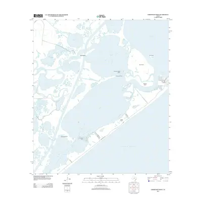
2013 Map of Christmas Point
USGS Topo · Published 2013About this map
Christmas Bay and the surrounding coastal wetlands define this intricate saltwater landscape along the Texas coast near Port Morris. The area is a complex network of barrier islands and tidal estuaries, where Bastrop Bayou and Big Slough feed into larger water bodies. The terrain is dominated by significant island formations such as Mud Island, Moodys Island, and Follets Island, which separate the bays from the Gulf of Mexico. Navigation and local geography are shaped by narrow passages like Cold Pass and San Luis Pass. These waterways are punctuated by hazardous submerged features and landmarks, including Christmas Point Reef and Arcadia Reef, illustrating the dynamic nature of this shoreline. On the mainland, a scatter of smaller basins like Alligator Lake and Wolf Lake suggests a low-lying environment highly sensitive to coastal changes.
Find a feature on this map
42 named features on this map. Tap any name to fly to it.
Don’t see what you’re looking for? This feature index may not catch every label — zoom into the map to look around manually.
Map Details
Editions of this 2013 Christmas Point Map
This is the sole edition of this map. No revisions or reprints were ever made.
Other maps of this area

1929 · Karankawa Lake
USGS Topo · 1:24,000

1933 · Karankawa Lake
USGS Topo · 1:31,680

1933 · San Luis Pass
USGS Topo · 1:31,680

1943 · San Luis Pass
USGS Topo · 1:31,680

1943 · Oyster Creek
USGS Topo · 1:31,680

1943 · Danbury
USGS Topo · 1:31,680

1943 · Freeport
USGS Topo · 1:31,680
1943 · Carancahua Lake
USGS Topo · 1:24,000

1943 · Christmas Point
USGS Topo · 1:24,000

1943 · Chocolate Bay
USGS Topo · 1:24,000