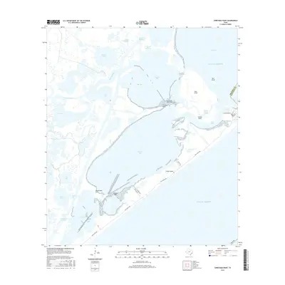
2016 Map of Christmas Point
USGS Topo · Published 2016About this map
The complex wetland and barrier island system of the Texas Gulf Coast is documented here, showing the intricate network of bays and inlets where the Brazoria and Galveston county line meets at San Luis Pass. This saltwater environment is defined by expansive bodies like Christmas Bay and Drum Bay, which are sheltered from the Gulf Of Mexico by Follets Island. The map illustrates the specialized nautical and coastal geography of the region, from the industrial path of the Intracoastal Waterway in the north to the numerous reefs and cuts essential to local navigation, such as Arcadia Reef and Cedar Cut. Named points like Rattlesnake Point and Christmas Point project into the shallow waters, while several named islands including Moodys Island and Mud Island break the surface of the estuaries. Modern coastal access is provided via the Blue Water HWY, connecting the sparse residential developments on San Luis Island.
Find a feature on this map
38 named features on this map. Tap any name to fly to it.
Don’t see what you’re looking for? This feature index may not catch every label — zoom into the map to look around manually.
Map Details
Editions of this 2016 Christmas Point Map
This is the sole edition of this map. No revisions or reprints were ever made.
Other maps of this area

1929 · Karankawa Lake
USGS Topo · 1:24,000

1933 · Karankawa Lake
USGS Topo · 1:31,680

1933 · San Luis Pass
USGS Topo · 1:31,680

1943 · San Luis Pass
USGS Topo · 1:31,680

1943 · Oyster Creek
USGS Topo · 1:31,680

1943 · Danbury
USGS Topo · 1:31,680

1943 · Freeport
USGS Topo · 1:31,680
1943 · Carancahua Lake
USGS Topo · 1:24,000

1943 · Christmas Point
USGS Topo · 1:24,000

1943 · Chocolate Bay
USGS Topo · 1:24,000