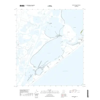
2019 Map of Christmas Point
USGS Topo · Published 2019About this map
Christmas Bay and the surrounding coastal marshlands define this stretch of the Texas Gulf Coast along the Brazoria and Galveston county line. The landscape is a complex network of shallow bays, reefs, and tidal passes, including Arcadia Reef and Christmas Point Reef, which dominate the central waters. The Intracoastal Waterway cuts through the western portion of the map, providing a vital shipping lane inland of the barrier islands. To the south and east, Follets Island and San Luis Island separate the protected interior waters from the Gulf of Mexico, joined at the natural opening of San Luis Pass. These islands are traced by the Blue Water Hwy, which serves as the primary coastal artery. The map captures the specialized geography of the Texas coast, where various sloughs like Alligator Slough and bayous like Bastrop Bayou drain into the vast bay system.
Find a feature on this map
39 named features on this map. Tap any name to fly to it.
Don’t see what you’re looking for? This feature index may not catch every label — zoom into the map to look around manually.
Map Details
Editions of this 2019 Christmas Point Map
This is the sole edition of this map. No revisions or reprints were ever made.
Other maps of this area

1929 · Karankawa Lake
USGS Topo · 1:24,000

1933 · Karankawa Lake
USGS Topo · 1:31,680

1933 · San Luis Pass
USGS Topo · 1:31,680

1943 · San Luis Pass
USGS Topo · 1:31,680

1943 · Oyster Creek
USGS Topo · 1:31,680

1943 · Danbury
USGS Topo · 1:31,680

1943 · Freeport
USGS Topo · 1:31,680
1943 · Carancahua Lake
USGS Topo · 1:24,000

1943 · Christmas Point
USGS Topo · 1:24,000

1943 · Chocolate Bay
USGS Topo · 1:24,000