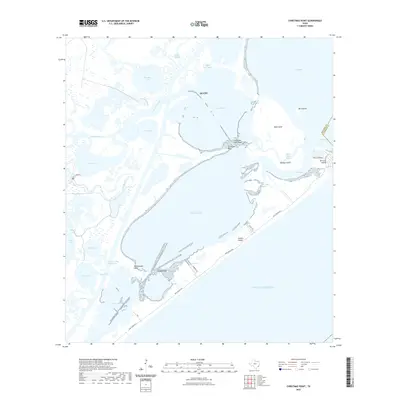
2022 Map of Christmas Point
USGS Topo · Published 2022About this map
Christmas Point stands as a prominent geographic marker where the waters of Bastrop Bay and Christmas Bay converge along the Texas Gulf Coast. This contemporary survey documents a complex estuarine landscape defined by shifting sandbars and protected oyster reefs, including Christmas Point Reef and Arcadia Reef. The shoreline is characterized by a dense network of bayous and sloughs, such as Bastrop Bayou and Alligator Slough, which feed into larger bodies like West Bay and Drum Bay.
Find a feature on this map
41 named features on this map. Tap any name to fly to it.
Don’t see what you’re looking for? This feature index may not catch every label — zoom into the map to look around manually.
Map Details
Editions of this 2022 Christmas Point Map
This is the sole edition of this map. No revisions or reprints were ever made.
Other maps of this area

1929 · Karankawa Lake
USGS Topo · 1:24,000

1933 · Karankawa Lake
USGS Topo · 1:31,680

1933 · San Luis Pass
USGS Topo · 1:31,680

1943 · San Luis Pass
USGS Topo · 1:31,680

1943 · Oyster Creek
USGS Topo · 1:31,680

1943 · Danbury
USGS Topo · 1:31,680

1943 · Freeport
USGS Topo · 1:31,680
1943 · Carancahua Lake
USGS Topo · 1:24,000

1943 · Christmas Point
USGS Topo · 1:24,000

1943 · Chocolate Bay
USGS Topo · 1:24,000