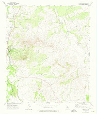
1972 Map of Christoval
USGS Topo · Published 1974About this map
The South Concho River valley anchors this early 1970s survey of Tom Green County, where the settlement of Christoval sits as a primary hub. The landscape is defined by the intersection of water and transport, with the Atchison Topeka and Santa Fe railroad paralleling the river corridor. This area served as a crucial transition point between the Edwards Plateau and the Permian Basin, evidenced by the scattered Oil Wells and Gravel Pits that dot the terrain near McKidrick Draw and Millers Branch.
Find a feature on this map
22 named features on this map. Tap any name to fly to it.
Don’t see what you’re looking for? This feature index may not catch every label — zoom into the map to look around manually.
Map Details
Editions of this 1972 Christoval Map
This is the sole edition of this map. No revisions or reprints were ever made.
Other maps of this area

1892 · San Angelo
USGS Topo · 1:125,000

1895 · Sherwood
USGS Topo · 1:125,000

1924 · San Angelo 2-c
USGS Topo · 1:48,000

1924 · Sherwood 1-d
USGS Topo · 1:48,000

1928 · Wall
USGS Topo · 1:62,500

1928 · Tankersly
USGS Topo · 1:62,500

1954 · San Angelo
USGS Topo · 1:250,000

1957 · Knickerbocker
USGS Topo · 1:62,500

1957 · Wall
USGS Topo · 1:62,500

1958 · San Angelo
USGS Topo · 1:250,000