
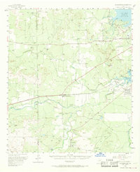
1957 Map of Knickerbocker
USGS Topo · Published 1958About this map
The Middle Concho River and Spring Creek converge toward the burgeoning water infrastructure of West Texas in the late 1950s. This survey records the landscape at a transitional moment, showing the San Angelo Reservoir and Lake Nasworthy north and south of the river fork. The settlement of Knickerbocker serves as a local hub near Dove Creek, while the surrounding plateau is defined by large family holdings such as the Mayer Ranch, Tweedy Ranch, and Kelly Ranch.
Find a feature on this map
39 named features on this map. Tap any name to fly to it.
Don’t see what you’re looking for? This feature index may not catch every label — zoom into the map to look around manually.
Map Details
Editions of this 1957 Knickerbocker Map
2 editions found
Other maps of this area

1891 · Hayrick
USGS Topo · 1:125,000

1892 · San Angelo
USGS Topo · 1:125,000

1894 · Hayrick
USGS Topo · 1:125,000

1895 · Sherwood
USGS Topo · 1:125,000

1924 · San Angelo 2-c
USGS Topo · 1:48,000

1924 · Sherwood 1-d
USGS Topo · 1:48,000

1924 · San Angelo 2-b
USGS Topo · 1:48,000

1924 · Sherwood 1-a
USGS Topo · 1:48,000

1928 · Wall
USGS Topo · 1:62,500

1928 · Tankersly
USGS Topo · 1:62,500