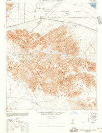
1944 Map of Chuckwalla Mountains
USGS Topo · Published 1956About this map
Desert Center serves as the primary outpost on the northern edge of this desert landscape, situated along the corridor of Routes 60 and 70. The terrain is dominated by the dense topographic contours of the Chuckwalla Mountains, where a localized mining economy is evidenced by operations such as the Red Cloud Mine, Lost Pony Mine, and Baumonk Mine. These sites, tucked into the canyons and ridges, suggest a mid-century period of extraction and exploration in a region where water sources were critical and sparse. The importance of these rare water points is highlighted by named features like Corn Springs, Aztec Well, and Gruendike Well, which provided essential lifelines for travelers and miners moving between the peaks and the Chuckwalla Valley. In the eastern reaches, Ship Creek drains toward the arid flats near Palen Dry Lake, defining the natural drainage patterns of this high-desert environment.
Find a feature on this map
20 named features on this map. Tap any name to fly to it.
Don’t see what you’re looking for? This feature index may not catch every label — zoom into the map to look around manually.
Map Details
Editions of this 1944 Chuckwalla Mountains Map
3 editions found
Other maps of this area

1940 · Frink
USGS Topo · 1:62,500

1940 · Iris Pass
USGS Topo · 1:62,500

1940 · Canyon Spring
USGS Topo · 1:62,500

1943 · Canyon Spring
USGS Topo · 1:62,500

1943 · Coxcomb Mountains
USGS Topo · 1:62,500

1944 · Eagle Tank
USGS Topo · 1:62,500

1944 · Chuckwalla Mountains
USGS Topo · 1:62,500

1944 · Coxcomb Mountains
USGS Topo · 1:62,500

1944 · Frink
USGS Topo · 1:62,500

1945 · Iris Pass
USGS Topo · 1:62,500