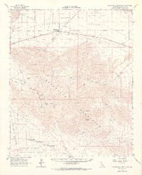
1963 Map of Chuckwalla Mountains
USGS Topo · Published 1968About this map
The remote expanse of the Chuckwalla Mountains and the Chuckwalla Valley reveal a landscape defined by 20th-century resource extraction and military utility. Mining activity is concentrated in the western reaches, where the Red Cloud Mine, Great Western Mine, and Lost Pony Mine are connected by a network of unimproved roads and jeep trails. To the north, the small outpost of Desert Center serves as a lone hub along Route 60, situated near a significant Pipeline and a Pumping Station.
Find a feature on this map
31 named features on this map. Tap any name to fly to it.
Don’t see what you’re looking for? This feature index may not catch every label — zoom into the map to look around manually.
Map Details
Editions of this 1963 Chuckwalla Mountains Map
3 editions found

Other maps of this area

1940 · Frink
USGS Topo · 1:62,500

1940 · Iris Pass
USGS Topo · 1:62,500

1940 · Canyon Spring
USGS Topo · 1:62,500

1943 · Canyon Spring
USGS Topo · 1:62,500

1943 · Coxcomb Mountains
USGS Topo · 1:62,500

1944 · Eagle Tank
USGS Topo · 1:62,500

1944 · Chuckwalla Mountains
USGS Topo · 1:62,500

1944 · Coxcomb Mountains
USGS Topo · 1:62,500

1944 · Frink
USGS Topo · 1:62,500

1945 · Iris Pass
USGS Topo · 1:62,500