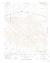
1963 Map of Chuckwalla Mountains
USGS Topo · Published 1981About this map
Desert Center sits at the northern edge of this high-desert landscape, serving as a hub for travelers and local operations during the early 1960s. The map reveals a complex history of extraction and transport, notably featuring the Mining Railroad and numerous prospects such as the Granite Mine, Great Western Mine, and Red Cloud Mine. These sites are linked by rugged tracks, including the historic Bradshaw Road, which cuts through the southern portion of the quadrangle.
Find a feature on this map
34 named features on this map. Tap any name to fly to it.
Don’t see what you’re looking for? This feature index may not catch every label — zoom into the map to look around manually.
Map Details
Editions of this 1963 Chuckwalla Mountains Map
3 editions found

Other maps of this area

1940 · Frink
USGS Topo · 1:62,500

1940 · Iris Pass
USGS Topo · 1:62,500

1940 · Canyon Spring
USGS Topo · 1:62,500

1943 · Canyon Spring
USGS Topo · 1:62,500

1943 · Coxcomb Mountains
USGS Topo · 1:62,500

1944 · Eagle Tank
USGS Topo · 1:62,500

1944 · Chuckwalla Mountains
USGS Topo · 1:62,500

1944 · Coxcomb Mountains
USGS Topo · 1:62,500

1944 · Frink
USGS Topo · 1:62,500

1945 · Iris Pass
USGS Topo · 1:62,500