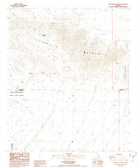
1988 Map of Chuckwalla Spring
USGS Topo · Published 1988About this map
The Chuckwalla Mountains dominate this high-desert landscape in southeastern California, where the rugged peaks separate the broad basins of Riverside and Imperial counties. Water is the primary driver of human presence in this arid region, as evidenced by the distribution of Chuckwalla Spring, Mesquite Spring, and a series of isolated water sources like Indian Well and Rainey Well. These points of relief were essential for the prospectors who left behind the scattered Prospects and the unnamed Mine located deep within the range. The southern portion of the map is defined by the Chocolate Mountain Aerial Gunnery Range, marking the intersection of military training grounds and public lands. The vast drainage of Arroyo Seco cuts across the lower plains, tracing a path toward the Little Chuckwalla Mountains and Graham Pass.
Find a feature on this map
13 named features on this map. Tap any name to fly to it.
Don’t see what you’re looking for? This feature index may not catch every label — zoom into the map to look around manually.
Map Details
Editions of this 1988 Chuckwalla Spring Map
2 editions found
Other maps of this area

1940 · Iris Pass
USGS Topo · 1:62,500

1944 · Chuckwalla Mountains
USGS Topo · 1:62,500

1945 · Iris Pass
USGS Topo · 1:62,500

1952 · Sidewinder Well
USGS Topo · 1:62,500

1953 · Chuckwalla Spring
USGS Topo · 1:62,500

1954 · Salton Sea
USGS Topo · 1:250,000

1955 · Salton Sea
USGS Topo · 1:250,000

1959 · Salton Sea
USGS Topo · 1:250,000

1963 · Salton Sea
USGS Topo · 1:250,000
1963 · Iris Pass
USGS Topo · 1:62,500