1944 Map of Chula
USGS Topo · Published 1944About this map
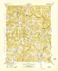
The Appomattox River carves a winding course through the Virginia countryside on the border of Powhatan and Amelia counties, serving as the primary geographic anchor for this mid-century survey. The landscape is defined by its rural social network, punctuated by community hubs like Grub Hill Church, Pleasant Grove Church, and Pine Grove Church. These religious centers, along with the scattered settlements of Chula and Fieldstown, illustrate a settlement pattern reliant on the intersection of country roads and natural drainage systems. Industrial activity is represented by Giles Mill near the northern boundary, while the Southern railroad line cuts through the southeastern quadrant, providing a vital transport link for the agrarian economy. A network of small waterways, including Flat Creek, Nibbs Creek, and Fighting Creek, feeds into the main river, shaping the rolling topography of the region during the 1940s.
Find a feature on this map
29 named features on this map. Tap any name to fly to it.
Don’t see what you’re looking for? This feature index may not catch every label — zoom into the map to look around manually.
Map Details
Editions of this 1944 Chula Map
This is the sole edition of this map. No revisions or reprints were ever made.
Other maps of this area

1890 · Goochland
USGS Topo · 1:125,000

1891 · Palmyra
USGS Topo · 1:125,000

1891 · Farmville
USGS Topo · 1:125,000

1892 · Goochland
USGS Topo · 1:125,000

1893 · Farmville
USGS Topo · 1:125,000

1895 · Palmyra
USGS Topo · 1:125,000

1897 · Amelia
USGS Topo · 1:125,000

1897 · Palmyra
USGS Topo · 1:125,000

1943 · Fine Creek Mills
USGS Topo · 1:31,680

1943 · Powhatan
USGS Topo · 1:31,680