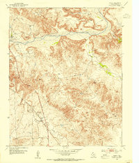
1953 Map of Chunky
USGS Topo · Published 1977About this map
The Panhandle and Santa Fe (AT&SF) Railroad cuts a prominent diagonal across this mid-century landscape, passing through the small station at Chunky. This Panhandle terrain is defined by the winding course of the Canadian River and its numerous tributaries, including Rosita Creek and Amarillo Creek. The map documents a working landscape of ranching and resource extraction during the early 1950s, featuring the Kritzer Ranch and LX Ranch alongside numerous Gravel Pits and a solitary Gas Well. Water sources were critical to this environment, as evidenced by the mapping of named points like Bullfrog Spring, Tincup Spring, and Bog Spring. These features, combined with markers like the Windcharger and scattered Windmills, illustrate the practical infrastructure required for livestock and industry in this portion of Potter County.
Find a feature on this map
22 named features on this map. Tap any name to fly to it.
Don’t see what you’re looking for? This feature index may not catch every label — zoom into the map to look around manually.
Map Details
Editions of this 1953 Chunky Map
3 editions found
Other maps of this area

1934 · Cliffside
USGS Topo · 1:62,500

1936 · Fourways
USGS Topo · 1:62,500

1936 · Cliffside
USGS Topo · 1:62,500

1939 · Sanford
USGS Topo · 1:62,500

1953 · Chunky
USGS Topo · 1:24,000

1953 · Marsh
USGS Topo · 1:24,000

1953 · Puente
USGS Topo · 1:24,000

1953 · Alibates Ranch
USGS Topo · 1:24,000

1953 · Pleasant Valley
USGS Topo · 1:24,000

1953 · Mayer
USGS Topo · 1:24,000