
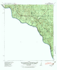
1940 Map of Chupadera
USGS Topo · Published 1959About this map
The Rio Grande carves a winding international boundary through this portion of Webb Co, where the Texas brush country meets the Mexican state of Coahuila. Based on field work by the Eighth Engineers just before the United States entered World War II, the map reveals a landscape defined by scarce water sources and ranching outposts. Chupadera Ranch sits as a primary center of activity in the interior, supported by nearby Chupadera Spring and the drainage of Chupadera Cr. To the south, isolated water points like Sullivan Spring and Loza Tank provide essential resources in the arid terrain, while Cathedral Rock serves as a prominent natural landmark for those navigating the rugged draws leading toward the river.
Find a feature on this map
12 named features on this map. Tap any name to fly to it.
Don’t see what you’re looking for? This feature index may not catch every label — zoom into the map to look around manually.
Map Details
Editions of this 1940 Chupadera Map
2 editions found
Other maps of this area

1923 · Palafox
USGS Topo · 1:62,500

1929 · Cotulla
USGS Topo · 1:125,000

1940 · Asherton
USGS Topo · 1:62,500

1940 · San Loranzo Creek
USGS Topo · 1:62,500

1941 · Botella Creek
USGS Topo · 1:62,500

1953 · Crystal City
USGS Topo · 1:250,000

1955 · Crystal City
USGS Topo · 1:250,000

1956 · Laredo
USGS Topo · 1:250,000

1957 · Indio Creek
USGS Topo · 1:62,500

1957 · Botella Creek
USGS Topo · 1:62,500