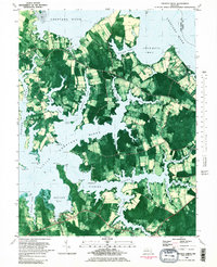
1982 Map of Church Creek
USGS Topo · Published 1982About this map
Choptank River and Little Choptank River dominate this 1980s orthophotomap of Dorchester County, revealing a landscape defined by its intricate shoreline and maritime heritage. Small settlements like Madison, Woolford, and Church Creek are connected by narrow roads such as Dailsville Road and Old Madison Rd, winding through a mosaic of agricultural fields and tidal marshes. The map provides a detailed view of local community hubs and religious sites, including the Antioch Cem Ch, Beckwith Ch, and the St Johns Cem Chapel near Hills Point.
Find a feature on this map
62 named features on this map. Tap any name to fly to it.
Don’t see what you’re looking for? This feature index may not catch every label — zoom into the map to look around manually.
Map Details
Editions of this 1982 Church Creek Map
2 editions found
Other maps of this area

1892 · Drum Point
USGS Topo · 1:62,500

1893 · Sharps Island
USGS Topo · 1:62,500

1898 · Choptank
USGS Topo · 1:125,000

1898 · St. Marys
USGS Topo · 1:125,000

1901 · Drum Point
USGS Topo · 1:62,500

1904 · Sharps Island
USGS Topo · 1:62,500

1904 · Oxford
USGS Topo · 1:62,500

1905 · Crapo
USGS Topo · 1:62,500

1905 · Drum Point
USGS Topo · 1:62,500

1906 · St. Marys
USGS Topo · 1:125,000