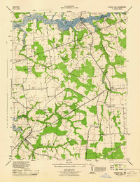
1944 Map of Church Hill
USGS Topo · Published 1944About this map
The Chester River forms a natural boundary between Kent and Queen Anne's counties in this 1944 survey, serving as a focal point for riverside landings like Ford Landing and Travilla Wharf. Inland, the landscape is defined by small agricultural settlements and a dense network of country roads, including McGinnes Road and Sudlersville Road. The area is notably rich in community landmarks, featuring numerous local congregations such as Home Missionary Church, Mt Pleasant Church, and Double Creek Church. At the southern edge of the map, the town of Church Hill stands as a primary hub, while the Pennsylvania railroad line cuts across the southeastern corner. The map details a rural Maryland economy transitioning through the mid-20th century, where small hamlets like Pondtown, with its Pondtown Sch, and Ewingville remained vital centers of local life.
Find a feature on this map
41 named features on this map. Tap any name to fly to it.
Don’t see what you’re looking for? This feature index may not catch every label — zoom into the map to look around manually.
Map Details
Editions of this 1944 Church Hill Map
This is the sole edition of this map. No revisions or reprints were ever made.
Other maps of this area

1898 · Tolchester
USGS Topo · 1:125,000

1899 · Dover
USGS Topo · 1:125,000

1900 · Cecilton
USGS Topo · 1:62,500

1900 · Betterton
USGS Topo · 1:62,500

1901 · Chestertown
USGS Topo · 1:62,500

1903 · Tolchester
USGS Topo · 1:125,000

1905 · Barclay
USGS Topo · 1:62,500

1906 · Dover
USGS Topo · 1:125,000

1908 · Tolchester
USGS Topo · 1:125,000

1920 · Dover
USGS Topo · 1:125,000