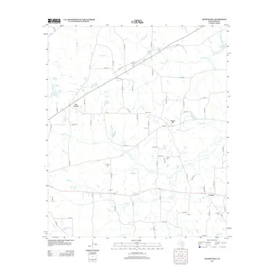
2013 Map of Church Hill
USGS Topo · Published 2013About this map
The community of Church Hill serves as the central focal point for this section of Rusk County, where local farm roads such as FM-3135 and Co RD-338 N intersect near the headwaters of Beard Br. The landscape is a network of small watercourses and family burial grounds that define the local genealogy, including the Turner Cem and Young Cem. To the southwest, Chapman sits along the southern highway corridor, while the northern reaches are marked by the presence of Martin Lake and Wasson Br.
Find a feature on this map
84 named features on this map. Tap any name to fly to it.
Don’t see what you’re looking for? This feature index may not catch every label — zoom into the map to look around manually.
Map Details
Editions of this 2013 Church Hill Map
This is the sole edition of this map. No revisions or reprints were ever made.
Other maps of this area

1935 · Henderson
USGS Topo · 1:48,000

1936 · Kilgore
USGS Topo · 1:48,000

1939 · Henderson
USGS Topo · 1:62,500

1940 · Kilgore
USGS Topo · 1:62,500

1956 · Tyler
USGS Topo · 1:250,000

1958 · Tatum
USGS Topo · 1:62,500

1960 · Minden
USGS Topo · 1:62,500
1971 · Kilgore SE
USGS Topo · 1:24,000

1973 · Henderson
USGS Topo · 1:24,000
1973 · Berryhill Creek
USGS Topo · 1:24,000