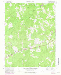
1963 Map of Church Road
USGS Topo · Published 1982About this map
Norfolk And Western railroad tracks cut a sharp diagonal across this landscape in the early 1960s, connecting the rural communities of Church Road and Walkers. This rail-oriented corridor is marked by Poole Siding, a localized stop within a terrain defined by the winding Namozine Creek and the southern edge of Lake Chesdin. The boundary between Amelia and Dinwiddie counties meanders through these wooded lowlands, often following the natural courses of waterways like Tylers Branch and Pucketts Branch.
Find a feature on this map
29 named features on this map. Tap any name to fly to it.
Don’t see what you’re looking for? This feature index may not catch every label — zoom into the map to look around manually.
Map Details
Editions of this 1963 Church Road Map
3 editions found
Other maps of this area

1897 · Amelia
USGS Topo · 1:125,000

1943 · Goodes Bridge
USGS Topo · 1:31,680

1943 · De Witt
USGS Topo · 1:24,000

1943 · Dinwiddie
USGS Topo · 1:24,000

1943 · Beach
USGS Topo · 1:24,000

1943 · Church Road
USGS Topo · 1:24,000

1943 · Winterpock
USGS Topo · 1:24,000

1943 · Sutherland
USGS Topo · 1:24,000

1943 · Richmond
USGS Topo · 1:250,000
1944 · Winterpock
USGS Topo · 1:31,680