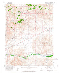
1957 Map of Churchill Butte
USGS Topo · Published 1963About this map
The Carson River winds through the southern reaches of this landscape, flanked by the Pine Nut Mountains and the historic Fort Churchill State Park. This mid-century survey records the region's deep mining heritage, marking specific operations such as the Ramsey Comstock Mine, Gooseberry Mine, and the Blackhawk Mine. The transition from active industrial hubs to historical markers is evident at Ramsey (Site) and Clifton (Site), indicating settlements that had already largely faded from the map by the 1950s. High-elevation terrain like the Virginia Range and Flowery Range dominates the northern half, while the Southern Pacific railroad line and the Churchill Landing Strip indicate the essential transportation corridors of the era. This document preserves the locations of numerous Springs and Gravel Pits essential for both ranching and infrastructure in the high desert.
Find a feature on this map
37 named features on this map. Tap any name to fly to it.
Don’t see what you’re looking for? This feature index may not catch every label — zoom into the map to look around manually.
Map Details
Editions of this 1957 Churchill Butte Map
3 editions found

Other maps of this area

1890 · Wadsworth
USGS Topo · 1:125,000

1891 · Carson
USGS Topo · 1:125,000

1891 · Wabuska
USGS Topo · 1:125,000

1891 · Reno
USGS Topo · 1:125,000

1892 · Wadsworth
USGS Topo · 1:125,000

1893 · Carson
USGS Topo · 1:125,000

1893 · Reno
USGS Topo · 1:125,000

1894 · Wadsworth
USGS Topo · 1:125,000

1894 · Wabuska
USGS Topo · 1:125,000

1950 · Virginia City
USGS Topo · 1:62,500