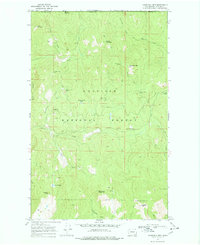
1969 Map of Churchill Mtn
USGS Topo · Published 1978About this map
Mining operations and remote trails define the landscape of Colville National Forest just south of the Canada United States border. This area in Stevens County is marked by a concentration of early extractive sites, including the Big Iron Mine, the White Horse Mine, and the Easter Sunday Mine, which sits near its namesake Easter Sunday Lake. The terrain is characterized by high peaks such as Churchill Mtn and Horns Mountain, with drainage provided by the American Fork and Big Sheep Creek. A network of trails and jeep paths connects these summits and mines, illustrating the historic access routes used by prospectors and forest rangers during the mid-20th century. The presence of Kiel Springs and Lamar Lake highlights the importance of water sources in this elevated, mountainous region.
Find a feature on this map
34 named features on this map. Tap any name to fly to it.
Don’t see what you’re looking for? This feature index may not catch every label — zoom into the map to look around manually.
Map Details
Editions of this 1969 Churchill Mtn Map
3 editions found
Other maps of this area

1929 · Colville
USGS Topo · 1:125,000

1933 · Colville
USGS Topo · 1:125,000

1936 · Marcus
USGS Topo · 1:96,000

1942 · Marcus
USGS Topo · 1:125,000

1948 · Orient
USGS Topo · 1:62,500

1951 · Orient
USGS Topo · 1:62,500

1954 · Okanogan
USGS Topo · 1:250,000

1958 · Okanogan
USGS Topo · 1:250,000

1958 · Sandpoint
USGS Topo · 1:250,000

1963 · Sandpoint
USGS Topo · 1:250,000