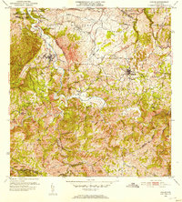
1953 Map of Ciales
USGS Topo · Published 1953About this map
The Río Grande de Manatí carves a deep, winding path through this central mountain region, serving as the physical divide between the municipalities of Ciales and Morovis. During the early 1950s, this landscape was defined by its complex network of barrios and agricultural estates, such as Hacienda Maria and Hato Viejo. The map documents a deeply spiritual and communal geography, pinpointing local landmarks like the Iglesia San Antonio, Iglesia del Niño Jesus, and the Capilla del Carmen. High elevations are marked by distinctive peaks including Cerro de la Bandera and Cerro Avispa, while the educational infrastructure is represented by the Escuela Segunda Unidad de Pesas. The intricate drainage system of named streams, such as the Quebrada de los Muertos and Quebrada de la Mina, underscores the area's steep topography and watershed importance.
Find a feature on this map
79 named features on this map. Tap any name to fly to it.
Don’t see what you’re looking for? This feature index may not catch every label — zoom into the map to look around manually.
Map Details
Editions of this 1953 Ciales Map
This is the sole edition of this map. No revisions or reprints were ever made.
Other maps of this area

1937 · Aguadilla
USGS Topo · 1:20,000

1937 · Moca
USGS Topo · 1:20,000

1938 · Alto Sano
USGS Topo · 1:20,000

1938 · San Sebastian
USGS Topo · 1:20,000

1938 · Quebradillas
USGS Topo · 1:20,000

1939 · Mayaguez
USGS Topo · 1:30,000

1941 · Moca
USGS Topo · 1:30,000

1941 · Rincon
USGS Topo · 1:30,000

1941 · Rincon
USGS Topo · 1:30,000

1941 · San Sebastian
USGS Topo · 1:30,000
Featured Places
- Sector Serrano, San Sebastián
- Sector La Grúa, Añasco
- Sector Los Crespos, San Sebastián
- Sector Ramos, San Sebastián
- Sector Los Ramos, Moca