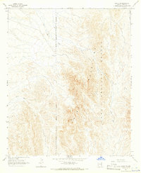
1965 Map of Cibola SE
USGS Topo · Published 1966About this map
The Trigo Mountains dominate this high-desert landscape in the mid-1960s, a region defined by its isolation and military significance. Large portions of the eastern terrain fall within the Yuma Proving Ground, marked by an Military Reservation Boundary (Indefinite). Historical mining activity is evident at the Hart Mine, situated along the drainages of Hart Mine Wash. The hydrology of the area is characterized by ephemeral desert watercourses, including the curiously named Crazy Woman Wash and Gould Wash to the north. Topographic highlights include the narrow passage of Needles Eye, while basic infrastructure is limited to a networked Jeep Trail and a solitary Gravel Pit. This survey captures the arid expanse before modern development, preserving the footprint of early resource extraction and federal land use.
Find a feature on this map
11 named features on this map. Tap any name to fly to it.
Don’t see what you’re looking for? This feature index may not catch every label — zoom into the map to look around manually.
Map Details
Editions of this 1965 Cibola SE Map
3 editions found
Other maps of this area

1934 · Trigo Peaks
USGS Topo · 1:48,000

1939 · Red Hill
USGS Topo · 1:62,500

1939 · Trigo Peaks
USGS Topo · 1:62,500

1942 · Blythe
USGS Topo · 1:250,000

1945 · Cibola
USGS Topo · 1:62,500

1945 · Picacho
USGS Topo · 1:62,500

1951 · Picacho
USGS Topo · 1:62,500

1951 · Cibola
USGS Topo · 1:62,500

1952 · Mule Wash
USGS Topo · 1:24,000

1952 · Palo Verde
USGS Topo · 1:24,000