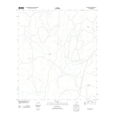
2012 Map of Cieneguita
USGS Topo · Published 2012About this map
The high desert landscape of Presidio County is defined here by the drainage networks of Cibolo Cr and Oso Cr, which carve through the arid terrain of the Trans-Pecos. The topography is dominated by dramatic elevations like Pico Tempico and the secluded Doll Canyon. Human presence is sparse, centered on the settlement of Cieneguita and the modern infrastructure of the Cibolo Creek Ranch Airport. This 2012 survey illustrates how the environment dictates settlement patterns in West Texas, where ranching and private aviation hubs utilize the flat stretches between rugged peaks and winding creek beds.
Find a feature on this map
6 named features on this map. Tap any name to fly to it.
Don’t see what you’re looking for? This feature index may not catch every label — zoom into the map to look around manually.
Map Details
Editions of this 2012 Cieneguita Map
This is the sole edition of this map. No revisions or reprints were ever made.
Other maps of this area

1895 · Marfa
USGS Topo · 1:125,000

1896 · Shafter
USGS Topo · 1:125,000

1959 · Presidio
USGS Topo · 1:250,000

1959 · Marfa
USGS Topo · 1:250,000

1965 · Presidio
USGS Topo · 1:250,000

1965 · Marfa
USGS Topo · 1:250,000
1979 · Chinati Peak
USGS Topo · 1:24,000

1983 · Shafter
USGS Topo · 1:24,000

1983 · Cuesta Del Burro East
USGS Topo · 1:24,000

1983 · Cienega Mountains
USGS Topo · 1:24,000