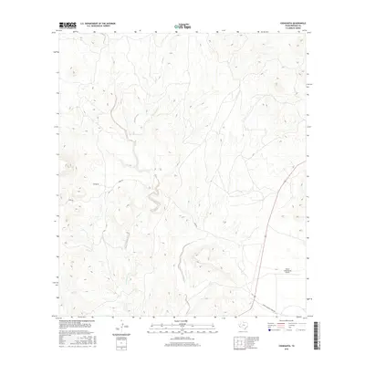
2016 Map of Cieneguita
USGS Topo · Published 2016About this map
Cibolo Creek carves a winding path through this portion of Presidio County, defining the drainage patterns of an arid landscape where water and elevation dictate the location of human activity. The settlement of Cieneguita is positioned west of the creek, served by the unpaved corridor of Sable Rd. This area reflects the modern ranching and aviation infrastructure of the Big Bend region, anchored by the Cibolo Creek Ranch Airport in the southeastern section. The terrain is marked by significant topographic relief, with drainage channels like those near Charco Bracero Creek Rd illustrating the complex erosion patterns typical of West Texas. The isolation of these features highlights the vast distances between established outposts in the high desert, where access is limited to a few primary ranch roads and private airstrips.
Find a feature on this map
6 named features on this map. Tap any name to fly to it.
Don’t see what you’re looking for? This feature index may not catch every label — zoom into the map to look around manually.
Map Details
Editions of this 2016 Cieneguita Map
This is the sole edition of this map. No revisions or reprints were ever made.
Other maps of this area

1895 · Marfa
USGS Topo · 1:125,000

1896 · Shafter
USGS Topo · 1:125,000

1959 · Presidio
USGS Topo · 1:250,000

1959 · Marfa
USGS Topo · 1:250,000

1965 · Presidio
USGS Topo · 1:250,000

1965 · Marfa
USGS Topo · 1:250,000
1979 · Chinati Peak
USGS Topo · 1:24,000

1983 · Shafter
USGS Topo · 1:24,000

1983 · Cuesta Del Burro East
USGS Topo · 1:24,000

1983 · Cienega Mountains
USGS Topo · 1:24,000