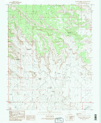
1989 Map of Cigarette Spring Cave
USGS Topo · Published 1989About this map
Valley of the Gods dominates the southern landscape of this San Juan County region, where the high plateau of Cedar Mesa breaks away into a complex network of canyons and sandstone monoliths. The 1989 provisional data shows a terrain defined by imaginative nomenclature, including the whimsical Rudolph and Santa Claus and the more formal De Gaulle and His Troops. This survey is notable for its specific cultural landmarks, such as the Cigarette Spring Cave USLM, which likely refers to a United States Location Monument used for mineral surveying. The drainage of Lime Creek carves through the central portion of the map, leading toward the distinct formations of Rooster Butte and Setting Hen Butte. While the area is primarily a study in physical geography, the inclusion of several Corrals and a Trans Line indicates the sparse but functional ranching and utility infrastructure present in this part of southeastern Utah during the late 20th century.
Find a feature on this map
23 named features on this map. Tap any name to fly to it.
Don’t see what you’re looking for? This feature index may not catch every label — zoom into the map to look around manually.
Map Details
Editions of this 1989 Cigarette Spring Cave Map
2 editions found
Other maps of this area

1886 · Abajo
USGS Topo · 1:250,000

1892 · Abajo
USGS Topo · 1:250,000

1893 · Abajo
USGS Topo · 1:250,000

1956 · Cortez
USGS Topo · 1:250,000

1958 · Cortez
USGS Topo · 1:250,000

1959 · Cortez
USGS Topo · 1:250,000

1962 · Cortez
USGS Topo · 1:250,000
1962 · Bluff NW
USGS Topo · 1:24,000

1962 · Bluff
USGS Topo · 1:62,500
1962 · Bluff SW
USGS Topo · 1:24,000