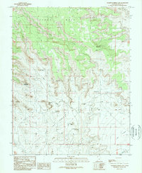
1989 Map of Cigarette Spring Cave
USGS Topo · Published 1989About this map
Valley of the Gods dominates the southern portion of this landscape, characterized by dramatic sandstone buttes and formations that define the region's geography. To the north, the elevation rises toward the expansive Cedar Mesa, where deep drainage systems like Lime Creek and the West Fork have carved into the plateau. The map is notable for the creative nomenclature given to its prominent rock features, such as the groupings known as De Gaulle and His Troops and Rudolph and Santa Claus.
Find a feature on this map
23 named features on this map. Tap any name to fly to it.
Don’t see what you’re looking for? This feature index may not catch every label — zoom into the map to look around manually.
Map Details
Editions of this 1989 Cigarette Spring Cave Map
2 editions found
Other maps of this area

1886 · Abajo
USGS Topo · 1:250,000

1892 · Abajo
USGS Topo · 1:250,000

1893 · Abajo
USGS Topo · 1:250,000

1956 · Cortez
USGS Topo · 1:250,000

1958 · Cortez
USGS Topo · 1:250,000

1959 · Cortez
USGS Topo · 1:250,000

1962 · Cortez
USGS Topo · 1:250,000
1962 · Bluff NW
USGS Topo · 1:24,000

1962 · Bluff
USGS Topo · 1:62,500
1962 · Bluff SW
USGS Topo · 1:24,000