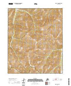
2018 Map of Circle A-2 NW
USGS Topo · Published 2018About this map
The high interior landscape of the Yukon-Koyukuk Census Area is defined here by a series of prominent drainages carving through the northern terrain. Waterways such as Grizzly Cr, Wolf Cr, and Sheep Cr serve as the primary landmarks in this undeveloped territory, where the topography rises sharply from the valley floors. Along the southern edge of the sheet, the boundary with the Fairbanks North Star Borough is noted, marking a administrative transition in an otherwise wild expanse.
Find a feature on this map
9 named features on this map. Tap any name to fly to it.
Don’t see what you’re looking for? This feature index may not catch every label — zoom into the map to look around manually.
Map Details
Editions of this 2018 Circle A-2 NW Map
This is the sole edition of this map. No revisions or reprints were ever made.
Other maps of this area

1951 · Circle
USGS Topo · 1:250,000

1955 · Circle B-3
USGS Topo · 1:63,360

1955 · Circle A-2
USGS Topo · 1:63,360

1955 · Circle A-3
USGS Topo · 1:63,360

1955 · Circle B-2
USGS Topo · 1:63,360

1955 · Circle
USGS Topo · 1:250,000

1964 · Circle
USGS Topo · 1:250,000
2018 · Circle A-2 SW
USGS Topo · 1:25,000
2018 · Circle A-2 SE
USGS Topo · 1:25,000
2018 · Circle A-2 NE
USGS Topo · 1:25,000