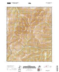
2018 Map of Circle B-4 NW
USGS Topo · Published 2018About this map
Twelvemile Summit serves as a prominent high-elevation landmark in this interior Alaskan landscape, marking the transition between the Fairbanks North Star Borough Yukon-Koyukuk Census Area boundary. The terrain is defined by its complex drainage network, where McKinley Cr and N Fork Birch Cr carve through high ridges. A central east-west corridor follows the path of Twelvemile Cr, a significant water body joined further south by the S Fork Twelvemile Cr. The elevation peaks at Table Mtn, providing a structural anchor for the surrounding hills. In the northeast corner, the curiously named Swamp Saddle indicates a high-altitude wetland or plateau between the peaks of the northern interior.
Find a feature on this map
18 named features on this map. Tap any name to fly to it.
Don’t see what you’re looking for? This feature index may not catch every label — zoom into the map to look around manually.
Map Details
Editions of this 2018 Circle B-4 NW Map
This is the sole edition of this map. No revisions or reprints were ever made.
Other maps of this area

1951 · Circle
USGS Topo · 1:250,000

1952 · Circle B-4
USGS Topo · 1:63,360

1952 · Circle C-4
USGS Topo · 1:63,360

1952 · Circle C-5
USGS Topo · 1:63,360

1954 · Circle C-5
USGS Topo · 1:63,360

1954 · Circle B-5
USGS Topo · 1:63,360

1955 · Circle
USGS Topo · 1:250,000

1964 · Circle
USGS Topo · 1:250,000
2018 · Circle B-5 NE
USGS Topo · 1:25,000
2018 · Circle B-5 SE
USGS Topo · 1:25,000