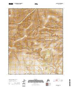
2018 Map of Circle C-2 NE
USGS Topo · Published 2018About this map
Boulder Hill rises as a prominent landmark in this interior Alaskan landscape, surveyed by the U.S. Geological Survey in 2018. The terrain is defined by a dense network of drainage systems, where the waters of Big Mosquito Cr and Little Mosquito Cr converge as they flow toward the southern edge of the quadrangle. To the north and east, the drainage becomes more complex with the presence of N Fork Crazy Cr and the main channel of Crazy Cr. The map reveals an uninhabited wilderness within the Yukon-Koyukuk Census Area, where traditional mining and trapping territories are often delineated by these watercourses. This modern survey provides precise topographic contours for features like Quartz Cr and Bluff Cr, tracing the natural corridors that have long dictated movement through the subarctic brush and tundra.
Find a feature on this map
16 named features on this map. Tap any name to fly to it.
Don’t see what you’re looking for? This feature index may not catch every label — zoom into the map to look around manually.
Map Details
Editions of this 2018 Circle C-2 NE Map
This is the sole edition of this map. No revisions or reprints were ever made.
Other maps of this area

1951 · Circle
USGS Topo · 1:250,000

1952 · Circle D-2
USGS Topo · 1:63,360

1955 · Circle C-2
USGS Topo · 1:63,360

1955 · Circle D-1
USGS Topo · 1:63,360

1955 · Circle C-1
USGS Topo · 1:63,360

1955 · Circle
USGS Topo · 1:250,000

1964 · Circle
USGS Topo · 1:250,000
2018 · Circle C-2 SE
USGS Topo · 1:25,000
2018 · Circle D-2 SW
USGS Topo · 1:25,000
2018 · Circle C-2 SW
USGS Topo · 1:25,000