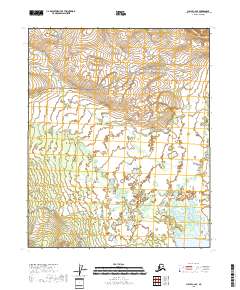
2018 Map of Circle C-2 SE
USGS Topo · Published 2018About this map
Central serves as the focal point for this interior Alaskan landscape, situated near the confluence of several prominent waterways. The terrain is defined by a dense network of meandering drainages, including the bifurcating Albert Cr and the winding course of Crooked Cr. To the south, the waters of Medicine Lake dominate the low-lying flats, reflecting the typical pond-and-muskeg hydrology of the Yukon-Koyukuk region.
Find a feature on this map
20 named features on this map. Tap any name to fly to it.
Don’t see what you’re looking for? This feature index may not catch every label — zoom into the map to look around manually.
Map Details
Editions of this 2018 Circle C-2 SE Map
This is the sole edition of this map. No revisions or reprints were ever made.
Other maps of this area

1951 · Circle
USGS Topo · 1:250,000

1955 · Circle B-1
USGS Topo · 1:63,360

1955 · Circle C-2
USGS Topo · 1:63,360

1955 · Circle B-2
USGS Topo · 1:63,360

1955 · Circle C-1
USGS Topo · 1:63,360

1955 · Circle
USGS Topo · 1:250,000

1964 · Circle
USGS Topo · 1:250,000
2018 · Circle C-2 SW
USGS Topo · 1:25,000
2018 · Circle C-1 NW
USGS Topo · 1:25,000
2018 · Circle B-2 NW
USGS Topo · 1:25,000