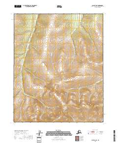
2018 Map of Circle C-4 SE
USGS Topo · Published 2018About this map
Pinnell Mtn and Porcupine Dome dominate this high-elevation landscape in the Yukon-Koyukuk region, defining a rugged watershed that feeds several prominent creeks. These peaks serve as the primary topographical anchors for the surrounding drainage systems, where the headwaters of Porcupine Cr and Loper Cr carve through the terrain. The map illustrates the convergence of these streams, including Willow Cr and Dome Cr, which indicate a complex hydrological network typical of the Alaska interior. This 2018 survey provides a clear view of the untouched geography before any significant modern development, focusing entirely on the natural elevations and watercourses that have historically shaped navigation and land use in the Circle mining district area.
Find a feature on this map
10 named features on this map. Tap any name to fly to it.
Don’t see what you’re looking for? This feature index may not catch every label — zoom into the map to look around manually.
Map Details
Editions of this 2018 Circle C-4 SE Map
This is the sole edition of this map. No revisions or reprints were ever made.
Other maps of this area

1951 · Circle
USGS Topo · 1:250,000

1952 · Circle B-4
USGS Topo · 1:63,360

1952 · Circle C-4
USGS Topo · 1:63,360

1955 · Circle B-3
USGS Topo · 1:63,360

1955 · Circle C-3
USGS Topo · 1:63,360

1955 · Circle
USGS Topo · 1:250,000

1964 · Circle
USGS Topo · 1:250,000
2018 · Circle B-4 NE
USGS Topo · 1:25,000
2018 · Circle C-3 NW
USGS Topo · 1:25,000
2018 · Circle C-4 NE
USGS Topo · 1:25,000