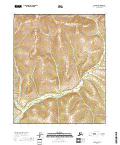
2018 Map of Circle B-4 NE
USGS Topo · Published 2018About this map
Birch Creek dominates this interior Alaska landscape, winding through a complex network of northern drainages within the Yukon-Koyukuk region. In this 2018 survey, the area remains largely defined by its natural watercourses and the sparse infrastructure characteristic of the territory. The presence of Eagle Creek Road in the eastern portion of the quadrangle provides a rare point of overland access to a terrain primarily shaped by historical mining and exploration interests. Tributaries such as Ptarmigan Cr and Gold Dust Cr flow through the elevations, names that often reflect the prospecting heritage of the Circle mining district. The drainage pattern, featuring the N Fork Birch Cr and Twelvemile Cr, reveals a landscape of high-latitude ridges and valleys where elevation contours define the limit of local travel and resource extraction.
Find a feature on this map
18 named features on this map. Tap any name to fly to it.
Don’t see what you’re looking for? This feature index may not catch every label — zoom into the map to look around manually.
Map Details
Editions of this 2018 Circle B-4 NE Map
This is the sole edition of this map. No revisions or reprints were ever made.
Other maps of this area

1951 · Circle
USGS Topo · 1:250,000

1952 · Circle B-4
USGS Topo · 1:63,360

1952 · Circle C-4
USGS Topo · 1:63,360

1955 · Circle B-3
USGS Topo · 1:63,360

1955 · Circle C-3
USGS Topo · 1:63,360

1955 · Circle
USGS Topo · 1:250,000

1964 · Circle
USGS Topo · 1:250,000
2018 · Circle C-4 SE
USGS Topo · 1:25,000
2018 · Circle B-3 SW
USGS Topo · 1:25,000
2018 · Circle B-4 SE
USGS Topo · 1:25,000