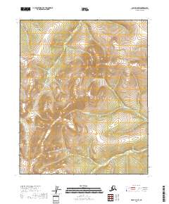
2018 Map of Circle C-5 SW
USGS Topo · Published 2018About this map
Preacher Cr and its northern tributary, N Fork Preacher Cr, dominate this high-latitude drainage basin within the Yukon-Koyukuk region. The landscape is defined by the severe topography of the interior, where elevation changes are meticulously tracked across t9n r6e, t9n r7e, t8n r6e, and t8n r7e. This 2018 survey reveals a terrain devoid of modern infrastructure or named settlements, highlighting the persistent wilderness character of the Alaska interior. Smaller drainages including Quartz Cr and Convert Cr feed into the primary waterways, illustrating the complex hydrologic network that shapes the surrounding ridges. The map provides a precise record of the natural landforms as they existed before further environmental or geomorphological shifts occurred in this remote part of the state.
Find a feature on this map
8 named features on this map. Tap any name to fly to it.
Don’t see what you’re looking for? This feature index may not catch every label — zoom into the map to look around manually.
Map Details
Editions of this 2018 Circle C-5 SW Map
This is the sole edition of this map. No revisions or reprints were ever made.
Other maps of this area

1951 · Circle
USGS Topo · 1:250,000

1951 · Circle C-6
USGS Topo · 1:63,360

1952 · Circle C-5
USGS Topo · 1:63,360

1954 · Circle C-5
USGS Topo · 1:63,360

1954 · Circle B-6
USGS Topo · 1:63,360
1954 · Circle C-6
USGS Topo · 1:63,360

1954 · Circle B-5
USGS Topo · 1:63,360

1955 · Circle
USGS Topo · 1:250,000

1964 · Circle
USGS Topo · 1:250,000
2018 · Circle B-5 NE
USGS Topo · 1:25,000