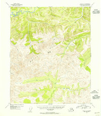
1954 Map of Circle C-6
USGS Topo · Published 1955About this map
White Mountains dominate this 1950s landscape in the Fourth Judicial Division, where the high point of Lime Peak serves as a primary surveying station. The terrain is defined by a dense network of drainages that feed the winding Beaver Creek at the northern edge of the sheet. To the south, the headwaters of Quartz Creek and Bear Creek carve through the limestone-heavy heights.
Find a feature on this map
11 named features on this map. Tap any name to fly to it.
Don’t see what you’re looking for? This feature index may not catch every label — zoom into the map to look around manually.
Map Details
Editions of this 1954 Circle C-6 Map
This is the sole edition of this map. No revisions or reprints were ever made.
Other maps of this area

1945 · Livengood
USGS Topo · 1:250,000

1951 · Livengood
USGS Topo · 1:250,000

1951 · Circle
USGS Topo · 1:250,000

1951 · Circle D-6
USGS Topo · 1:63,360

1951 · Livengood C-1
USGS Topo · 1:63,360

1951 · Circle C-6
USGS Topo · 1:63,360

1952 · Livengood D-1
USGS Topo · 1:63,360

1952 · Circle D-5
USGS Topo · 1:63,360

1952 · Circle C-5
USGS Topo · 1:63,360

1954 · Circle C-5
USGS Topo · 1:63,360