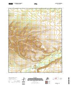
2018 Map of Circle D-4 SE
USGS Topo · Published 2018About this map
Preacher Creek meanders through this section of the Yukon-Koyukuk Census Area, defining the drainage patterns of a landscape marked by substantial topographical relief. The map traces the winding courses of Discovery Cr and Loper Cr as they cut through the interior. This 2018 survey reveals a terrain largely defined by its natural hydrology, with clearly demarcated township boundaries like t12n r10e and t11n r11e providing the primary human-imposed structure. The lack of roads or established settlements highlighted in the survey underscores the isolated character of this region, where the steep contour intervals suggest a landscape shaped by persistent water action and elevation changes between the creek beds and surrounding heights.
Find a feature on this map
7 named features on this map. Tap any name to fly to it.
Don’t see what you’re looking for? This feature index may not catch every label — zoom into the map to look around manually.
Map Details
Editions of this 2018 Circle D-4 SE Map
This is the sole edition of this map. No revisions or reprints were ever made.
Other maps of this area

1951 · Circle
USGS Topo · 1:250,000

1952 · Circle D-4
USGS Topo · 1:63,360

1952 · Circle D-3
USGS Topo · 1:63,360

1952 · Circle C-4
USGS Topo · 1:63,360

1955 · Circle C-3
USGS Topo · 1:63,360

1955 · Circle
USGS Topo · 1:250,000

1964 · Circle
USGS Topo · 1:250,000
2018 · Circle D-4 NE
USGS Topo · 1:25,000
2018 · Circle D-3 NW
USGS Topo · 1:25,000
2018 · Circle D-4 NW
USGS Topo · 1:25,000