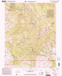
2001 Map of Circleville Mountain
USGS Topo · Published 2003About this map
Fishlake National Forest defines this high-elevation landscape, where the intersections of Beaver, Piute, Garfield, and Iron counties meet among the peaks. The area is a significant hydrological hub, centered on the Meadow River and the sprawling Kents Lake recreation area. This mapping highlights the development of water resources and mountain access, featuring sites like the Anderson Meadow Reservoir and the Diversion Dam. Lower down, family-named landmarks and seasonal habitations such as Fullmers Cabins and Wards Cache suggest a history of grazing and timber use. High-altitude meadows like Buck Pastures and Ranger Pasture are connected by a network of drainage systems, including the Middle Fork and South Fork of the Beaver River. The topography transitions from the dramatic height of Circleville Mountain down to the relative flats of Burnt Flat and Little Dog Valley.
Find a feature on this map
69 named features on this map. Tap any name to fly to it.
Don’t see what you’re looking for? This feature index may not catch every label — zoom into the map to look around manually.
Map Details
Editions of this 2001 Circleville Mountain Map
This is the sole edition of this map. No revisions or reprints were ever made.
Other maps of this area

1885 · Beaver
USGS Topo · 1:250,000

1937 · Delano Peak
USGS Topo · 1:48,000

1943 · Delano Peak
USGS Topo · 1:62,500

1953 · Richfield
USGS Topo · 1:250,000

1954 · Beaver SE
USGS Topo · 1:24,000

1958 · Richfield
USGS Topo · 1:250,000

1958 · Beaver
USGS Topo · 1:62,500

1966 · Bull Rush Peak
USGS Topo · 1:24,000

1966 · Circleville
USGS Topo · 1:24,000

1966 · Fremont Pass
USGS Topo · 1:24,000