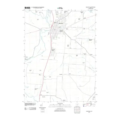
2010 Map of Circleville
USGS Topo · Published 2010About this map
Circleville serves as the central hub of this Pickaway County landscape, situated where the Scioto River meets Hargus Creek. The map documents a high density of ancestral sites, including numerous family-named burial grounds such as Rife Farm Cemetery, Shortridge Farm Cemetery, and the Shelby Farm Cemetery. Notable cultural landmarks include the Burning Indian Mound near Huber Hitler Rd and the Pickaway County Fairgrounds. The geography is defined by the broad Pickaway Plains and smaller residential developments like Knollwood Village and Eastmoor Subdivision. Aviation history is present at both Thomas Airport and the Pickaway County Memorial Airport, while the legacy of early transit is preserved in labels like Canal Rd following the river corridor.
Find a feature on this map
83 named features on this map. Tap any name to fly to it.
Don’t see what you’re looking for? This feature index may not catch every label — zoom into the map to look around manually.
Map Details
Editions of this 2010 Circleville Map
This is the sole edition of this map. No revisions or reprints were ever made.
Other maps of this area

1906 · Chillicothe
USGS Topo · 1:62,500

1908 · Chillicothe
USGS Topo · 1:62,500

1911 · Era
USGS Topo · 1:62,500

1912 · Roxabell
USGS Topo · 1:62,500

1913 · Era
USGS Topo · 1:62,500

1914 · Roxabell
USGS Topo · 1:62,500

1914 · Circleville
USGS Topo · 1:62,500

1943 · Era
USGS Topo · 1:62,500

1943 · Circleville
USGS Topo · 1:62,500

1944 · Roxabell
USGS Topo · 1:62,500