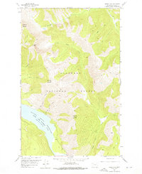
1958 Map of Circus Peak
USGS Topo · Published 1976About this map
The South Fork Flathead River corridor defines this portion of the Flathead National Forest, shown here shortly after the creation of the Hungry Horse Reservoir. The map illustrates the dramatic shift from riverine to lacustrine environment, with the reservoir's fingers reaching into former creek beds like Brush Creek and Park Creek. High-elevation landmarks such as Prospector Mountain, Circus Peak, and Dry Park Mountain tower over the drainage basins, their slopes marked by numerous named watercourses including Toboggan Creek and Bergsicker Creek. Transportation in this wilderness setting is limited to primitive routes like the Lower Twin Trail and various unnamed pack trails, reflecting a landscape managed for conservation and resource protection in the mid-20th century. The intricate contour work reveals the steep transition from the water's edge at 3,560 feet to peaks exceeding 7,000 feet.
Find a feature on this map
22 named features on this map. Tap any name to fly to it.
Don’t see what you’re looking for? This feature index may not catch every label — zoom into the map to look around manually.
Map Details
Editions of this 1958 Circus Peak Map
2 editions found
Other maps of this area

1913 · Marias Pass
USGS Topo · 1:125,000

1914 · Nyack
USGS Topo · 1:125,000

1936 · Silvertip
USGS Topo · 1:96,000

1942 · Silvertip
USGS Topo · 1:125,000

1955 · Choteau
USGS Topo · 1:250,000

1957 · Choteau
USGS Topo · 1:250,000

1958 · Choteau
USGS Topo · 1:250,000

1958 · Circus Peak
USGS Topo · 1:24,000

1958 · Nimrod
USGS Topo · 1:24,000

1958 · Quintonkon
USGS Topo · 1:24,000