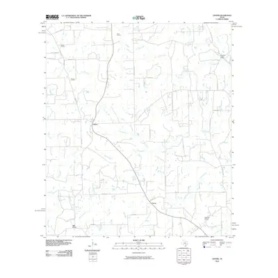
2010 Map of Cistern
USGS Topo · Published 2010About this map
Cistern serves as the central hub of this Fayette County landscape, where the local road network converges near the upper reaches of Bishop Branch. The area is defined by a sparse settlement pattern of small communities like Colony and Elm Grove, connected by a web of rural routes such as Anchor Ranch Loop and Rosanky Rd. This 2010 survey records a landscape shaped by both generational heritage and modern industry, evidenced by the presence of family-named burial grounds like Psencik Cemetery and Robbins Cemetery alongside the Southwest Muldoon Oil Field in the southeast. Waterways including Live Oak Creek and Pin Oak Creek wind through the territory, crossed by local landmarks like the Buckners Creek Bridge. The map details a transition from traditional agricultural holdings to active energy extraction, providing a clear record of land use at the end of the century's first decade.
Find a feature on this map
41 named features on this map. Tap any name to fly to it.
Don’t see what you’re looking for? This feature index may not catch every label — zoom into the map to look around manually.
Map Details
Editions of this 2010 Cistern Map
This is the sole edition of this map. No revisions or reprints were ever made.
Other maps of this area

1901 · Flatonia
USGS Topo · 1:125,000

1953 · Seguin
USGS Topo · 1:250,000
1958 · West Point
USGS Topo · 1:24,000

1958 · Seguin
USGS Topo · 1:250,000

1964 · Waelder
USGS Topo · 1:24,000

1964 · Jeddo
USGS Topo · 1:24,000
1964 · Rosanky
USGS Topo · 1:24,000
1964 · Togo
USGS Topo · 1:24,000

1965 · Muldoon
USGS Topo · 1:24,000

1965 · Cistern
USGS Topo · 1:24,000