
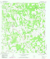
1965 Map of Cistern
USGS Topo · Published 1967About this map
Cistern serves as a central hub in this rural landscape of the mid-1960s, surrounded by family-named burial grounds that speak to generations of settlement. Small communities like Colony and Elm Grove anchor the southern reaches of the map, while the terrain is deeply etched by watercourses such as Peach Creek and Buckners Creek. The land use transition here is evident, as traditional agriculture and scattered homesteads share the landscape with industrial activities, including numerous Oil Wells and a Drill Hole.
Find a feature on this map
22 named features on this map. Tap any name to fly to it.
Don’t see what you’re looking for? This feature index may not catch every label — zoom into the map to look around manually.
Map Details
Editions of this 1965 Cistern Map
2 editions found
Other maps of this area

1901 · Flatonia
USGS Topo · 1:125,000

1953 · Seguin
USGS Topo · 1:250,000
1958 · West Point
USGS Topo · 1:24,000

1958 · Seguin
USGS Topo · 1:250,000

1964 · Waelder
USGS Topo · 1:24,000

1964 · Jeddo
USGS Topo · 1:24,000
1964 · Rosanky
USGS Topo · 1:24,000
1964 · Togo
USGS Topo · 1:24,000

1965 · Muldoon
USGS Topo · 1:24,000

1965 · Flatonia
USGS Topo · 1:24,000