
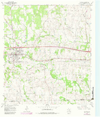
1965 Map of Flatonia
USGS Topo · Published 1967About this map
Flatonia serves as a significant rail and transit hub in the mid-1960s, situated where the Southern Pacific line intersects the landscape. The map reveals the evolution of the area through the existence of Old Flatonia and its corresponding Old Flatonia Cemetery to the south, indicating a shift in the primary settlement center toward the railroad. Cultural heritage is deeply etched into the terrain near the small community of Praha, which is marked by the Slavonic Cemetery. The landscape is a mix of agricultural utility and natural drainage, with several branches of Mulberry Creek and Rocky Creek cutting through the countryside. Evidence of local industry and infrastructure is present in several Gravel Pits, a Claypit, and the Flatonia Airport. This period captures the region just as modern interstate travel was beginning to reshape the corridor north of the established town center.
Find a feature on this map
38 named features on this map. Tap any name to fly to it.
Don’t see what you’re looking for? This feature index may not catch every label — zoom into the map to look around manually.
Map Details
Editions of this 1965 Flatonia Map
2 editions found
Other maps of this area

1901 · Flatonia
USGS Topo · 1:125,000

1919 · Schulenburg
USGS Topo · 1:62,500

1953 · Seguin
USGS Topo · 1:250,000

1956 · La Grange
USGS Topo · 1:62,500

1958 · Seguin
USGS Topo · 1:250,000

1965 · Muldoon
USGS Topo · 1:24,000

1965 · Schulenburg
USGS Topo · 1:24,000

1965 · Cistern
USGS Topo · 1:24,000
1965 · Swiss Alp
USGS Topo · 1:24,000

1965 · Komensky
USGS Topo · 1:24,000