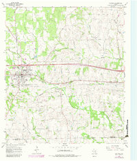
1965 Map of Flatonia
USGS Topo · Published 1982About this map
The Southern Pacific railroad corridor anchors this survey of central Texas, where the town of Flatonia serves as a primary regional hub. The map captures a landscape of transition, preserving the location of Old Flatonia and the Old Flatonia Cem south of the modern town site, alongside the historic Czech settlement of Praha. This area is dense with genealogical markers, including numerous small burial grounds such as the Slavonic Cem, Criswell Cem, and Pine Springs Cem.
Find a feature on this map
37 named features on this map. Tap any name to fly to it.
Don’t see what you’re looking for? This feature index may not catch every label — zoom into the map to look around manually.
Map Details
Editions of this 1965 Flatonia Map
2 editions found

Other maps of this area

1901 · Flatonia
USGS Topo · 1:125,000

1919 · Schulenburg
USGS Topo · 1:62,500

1953 · Seguin
USGS Topo · 1:250,000

1956 · La Grange
USGS Topo · 1:62,500

1958 · Seguin
USGS Topo · 1:250,000

1965 · Muldoon
USGS Topo · 1:24,000

1965 · Schulenburg
USGS Topo · 1:24,000

1965 · Cistern
USGS Topo · 1:24,000
1965 · Swiss Alp
USGS Topo · 1:24,000

1965 · Komensky
USGS Topo · 1:24,000