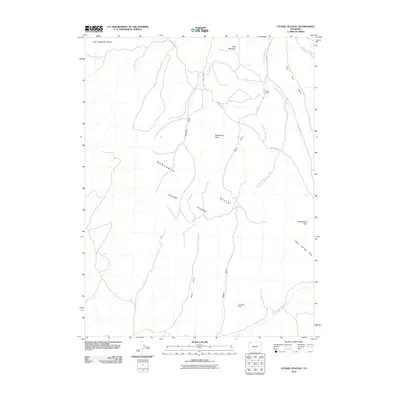
2010 Map of Citadel Plateau
USGS Topo · Published 2010About this map
Citadel Plateau and the Danforth Hills define this high-altitude landscape in Moffat County, where a network of seasonal drainages and named gulches carves through the terrain. The map documents a sparsely populated ranching region, anchored by the Shelton Ranch in the north and Keystone Ranch to the south. These properties are connected by high-desert infrastructure like County Rd 23 and County Rd 59, which navigate the complex topography of Freeman Gulch and Pinto Gulch. Prominent landforms such as Steamboat Rock and Wolf Mountain serve as significant local landmarks for orientation. The presence of Indian Springs Draw and Deep Channel Creek highlights the drainage patterns essential to the area's agricultural and pastoral operations in the early 21st century.
Find a feature on this map
19 named features on this map. Tap any name to fly to it.
Don’t see what you’re looking for? This feature index may not catch every label — zoom into the map to look around manually.
Map Details
Editions of this 2010 Citadel Plateau Map
This is the sole edition of this map. No revisions or reprints were ever made.
Other maps of this area

1907 · White River
USGS Topo · 1:125,000

1910 · White River
USGS Topo · 1:125,000

1954 · Vernal
USGS Topo · 1:250,000

1958 · Vernal
USGS Topo · 1:250,000

1958 · Citadel Plateau
USGS Topo · 1:62,500

1960 · Vernal
USGS Topo · 1:250,000

1960 · Elk Springs
USGS Topo · 1:62,500
1966 · White Rock
USGS Topo · 1:24,000
1966 · Smizer Gulch
USGS Topo · 1:24,000
1966 · Indian Valley
USGS Topo · 1:24,000