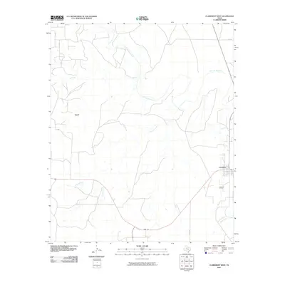
2010 Map of Clairemont West
USGS Topo · Published 2010About this map
Clairemont stands as the primary settlement in this stretch of West Texas, situated near the intersection of several regional routes and the winding Salt Fork Brazos River. The landscape is defined by the drainage networks of Salt Creek, Fourmile Creek, and Butte Creek, which cut through the high plains. Economic activity is anchored in the petroleum industry, evidenced by the presence of the Salt Creek Oil Field and the Clairemont Oil Field. These fields suggest a landscape where energy extraction coexists with cattle ranching, a common pattern in the Texas Rolling Plains. The map details a sparse road network, including Co RD 108 and Co RD 489, which connect isolated homesteads and industrial sites to the small hub at Clairemont.
Find a feature on this map
13 named features on this map. Tap any name to fly to it.
Don’t see what you’re looking for? This feature index may not catch every label — zoom into the map to look around manually.
Map Details
Editions of this 2010 Clairemont West Map
This is the sole edition of this map. No revisions or reprints were ever made.
Other maps of this area

1954 · Lubbock
USGS Topo · 1:250,000

1959 · Girard
USGS Topo · 1:24,000

1968 · Spur SW
USGS Topo · 1:24,000

1968 · White Camp
USGS Topo · 1:24,000

1969 · Cooper Mountain
USGS Topo · 1:24,000

1969 · Clairemont East
USGS Topo · 1:24,000

1969 · Clairemont West
USGS Topo · 1:24,000

1969 · T-O Creek
USGS Topo · 1:24,000
1969 · Gant Hills
USGS Topo · 1:24,000
1969 · Polar
USGS Topo · 1:24,000