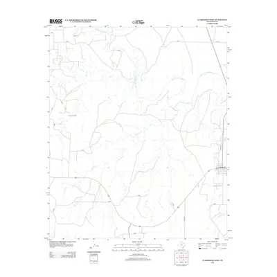
2012 Map of Clairemont West
USGS Topo · Published 2012About this map
Clairemont stands as the primary settlement in this corner of Kent County, positioned near the eastern edge of the survey where local streets like 7th St and 8th St define the small community grid. The landscape is heavily influenced by the winding path of the Salt Fork Brazos River, which cuts through the northern and eastern sections of the quadrangle. This area of West Texas is marked by its petroleum industry, evidenced by the extensive Salt Creek Oil Field in the west and the Clairemont Oil Field just south of the townsite. Numerous watercourses, including Salt Cr, Fourmile Cr, and Butte Cr, carve through the terrain, illustrating the drainage patterns that feed into the Brazos River system. The infrastructure is characterized by a network of rural routes such as Co Rd-203 and Co Rd-409, providing access to the distributed oil production sites and remote ranch lands.
Find a feature on this map
21 named features on this map. Tap any name to fly to it.
Don’t see what you’re looking for? This feature index may not catch every label — zoom into the map to look around manually.
Map Details
Editions of this 2012 Clairemont West Map
This is the sole edition of this map. No revisions or reprints were ever made.
Other maps of this area

1954 · Lubbock
USGS Topo · 1:250,000

1959 · Girard
USGS Topo · 1:24,000

1968 · Spur SW
USGS Topo · 1:24,000

1968 · White Camp
USGS Topo · 1:24,000

1969 · Cooper Mountain
USGS Topo · 1:24,000

1969 · Clairemont East
USGS Topo · 1:24,000

1969 · Clairemont West
USGS Topo · 1:24,000

1969 · T-O Creek
USGS Topo · 1:24,000
1969 · Gant Hills
USGS Topo · 1:24,000
1969 · Polar
USGS Topo · 1:24,000